
» Ville fjell og vennlige mennesker
» Nepalsk ornitolog kikket pa Lista
» Namaste Nepal passer for reiseskildringer


&
Temparature
Fixed Departure Programs 2014/2015
Upper Dolpo and Shey Gompa Trek - 27 Days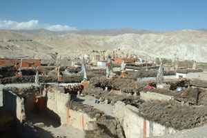
Ba-Yul, the hidden land of Dolpo, was first settled by Rokpa farmers and Drokpa nomads from Tibet in the 10th century. It is one of the highest inhabited places on earth, with scattered fortress-like villages and monasteries nestling amongst mountains of stark, ascetic beauty. Though part of Nepal today, Dolpo remains culturally and economically firmly tied to Tibet, where the people of this desolate area are cut off from their southern neighbors by snow-covered passes for much of the year. This is one of the most fascinating and difficult country to travel in.
Most of Dolpo is protected by Shey Phoksumdo National Park. It is bounded in the east and south by Dhaulagiri and Churen Himal ranges and in the west by the Jumla district. Dolpo has been bypassed by development and until recently by tourism. Although a few Anthropologists and geographers had explored the region, the entire district was closed to foreigners until 1989, when the southern parts of Dolpo were opened to organized trekking groups.
Peter Matthiessen's ‘The snow leopard’ and David Snellgrove's ‘Himalayan Pilgrimage’ have contributed to the mystique and attraction of Dolpo. Both writers visited the Shey Gompa, to the north of the Phoksumdo Lake, in inner Dolpo. This is the goal of most trekkers but this Dolpo trek will take you even further into this mysterious land…
Dolpo is a Bon-pro country, where people practice a shamanistic religion predating Tibetan Buddhism.
Much of Bon-po symbolism is the opposite of Buddhist practice. You should walk to the right of ancient mud chortens, which are inscribed with swastikas with their arms pointing in the opposite direction to the Buddhist chant of "om mani padme hum", the Bon-pos chant 'om ma tri mu ye sa le du", in Tibetan this translates as "in clarity unite'.
Phoksumdo Lake:
The lake is spectacular as it is 4.8km long, 1.8km wide and said to be 650m deep. It is known for its aquamarine color; a greenish blue similar to a special Tibetan turquoise .There is no aquatic life in the lake, which helps to make the waters brilliantly clear. If you toss a rock in, you can watch it for a long time as it sinks to the bottom. According to legend, Phoksumdo Lake was formed by a spiteful female demon.
In the Buddhist Himalaya, David Snellgrove recounts how the demon was fleeing from the saint Padmasambhava and gave the village people a turquoise after they promised not to say that she had passed by. Padmasambhava turned the turquoise into a lump of dung, which upset the local people so much they revealed the demon's whereabouts. She, with revenge, caused a flood. It is also said you can see the remains of a village below the lake's surface.
Detail Itinerary for upper Dolpo
Itinerary
Day 01 Arrival in Kathmandu, meet and transfer to hotel and evening well come dinner.
The Kathmandu Valley has an exotic setting. It is surrounded by a tier of green
Mountain wall above which tower mighty snow-capped peaks. It consists of
Three Main towns of great historic, artistic and culture interest: Kathmandu,
Patan and Bhaktapur. The Kathmandu valley covers an area of 218 sq. miles. It
Is situated 4223 ft. above sea-level.
Day 02 Sightseeing in Swoyambhu, Pashupati Boudhanath. And ktm Durbar square
Swoyambhu.
The history of the Valley, according to the legends, begins with Swoyambhu, or
The “the self-existent”. In times uncharted by history, Bodhisattva Manjusri
Came Across a beautiful lake during his travel. He saw a lotus that emitted
Brilliant Light at the lake’s center, so he cut a gorge in a southern hill and
Drained the Waters to worship the lotus. Men called it the Kathmandu Valley.
From then on, The hilltop of the Self-existent Lord has been a holy place.
Pashupati:
One-day lord Shiva got tired of this glittering palace on Mt. Kailash, his armies
Of ghosts and spirits, and even Parbati – his beautiful wife. Through his cosmic
Powers, he searched for a perfect place where he could holiday. Without telling
Anyone, he ran away from his palace and came to live in Slesmantak forest in
The Kathmandu valley. He gained great fame here as Pashupati – Lord of the
Animals –before other gods discovered his hiding place and came to fetch him.
The Pashupati where he stayed has received the attention of worshippers for at
Least fifteen hundred years; it is the holiest Hindu pilgrimage destination in
Nepal
Boudhanath
Boudhanath is among the largest stupa in south Asia, and it has become the focal point of Tibetan Buddhism in Nepal. The white mound looms thirty-six meters overhead. The stupa is located on the ancient trade route to Tibet, and Tibetan merchants rested and offered prayers here for many centuries. When refugees entered Nepal from Tibet in the 1950s, many of them decided to live around Boudhanath. They established many gompas, and the “Lit the Tibet” of Nepal was born. This “Little Tibet” is still the best place in the valley to observe Tibetan lifestyle. Monks walk about in maroon robes. Tibetans walk with prayer wheels in their hands and the rituals of prostration are presented to the Buddha as worshippers circumambulate the stupa on their hands and knees, bowing down to their lord.
Kathmandu Durbar Square
It is easy to be overwhelmed by the seemingly uncountable monuments in the Kathmandu Durbar Square. The house of the Living goddess, the ferocious Kal Bhairab, the red monkey god, and hundreds of erotic carvings are a few examples of the sights at the square! The building here is the greatest achievements of the Malla dynasty, and they resulted from the great rivalry between the three palaces of Kathmandu, Patan and Bhaktapur. The valley was divided among the children of Yaksya Malla. For visitors today, and for the Nepalese, it was serendipitous that they, and later their off springs, began artistic warfare trying to outdo each other in splendid constructions. Kings copied every thing their neighbors built in an even grander style. A visitor who wanders around the Square will see a round temple in the Pagoda architectural style, the temple of goddess Taleju (who played dice with King Jaya Prakash Malla), and an image of Shiva and Parbati sitting together among the many monuments.
Day by day details itinerary
Day 01: Arrival in Kathmandu
It is a panoramic thrill flying into Kathmandu on a clear day. The views of snow-capped mountain peaks sprawling down below you are almost ecstatic, beginning a whole chain of memorable experiences that stay with you for a long, long time. A representative and driver from our office will meet you at the airport and escort you to your hotel. The representative will help you check into your designated hotel. At the hotel you will be briefed about your daily activities.
Day 02: Sightseeing of Kathmandu Valley
Kathmandu is the historical and cultural heart of Nepal and has been a popular destination for tourists ever since Nepal opened its doors to visitors. The city presents a wonderful mix of Hinduism, Tibetan Buddhism and Western influence in the Valley. Patan and Bhaktapur, its two major neighboring cities bear immense historical, cultural and religious significances. There will be a half day guided tour to the famous and biggest Hindu shrine of Pashupatinath, the largest Buddhist stupa in Nepal Boudhanath, the 15th century Palace of 55 windows and Swoyambhunath.
Day 03: Fly to Nepalgunj
We fly from Kathmandu to Nepalgunj, which lies in the southwest part of the Terai, right on the border to India. After checking into our hotel we might visit the Bageshwari Mandir, a temple to honour Goddess Kali. Nepalgunj is known for its local bazaars, which have goods with cheap price rates. Here, not only do we see people from all over Nepal, but also people from Tibet and India; they all come here for trade.
Day 04: Fly to Juphal [2500m], Trek to Dunai [2100m]
We take an early morning flight to Juphal. Dolpo flights are always scheduled early in the morning. This is because high winds in the Thulo Bheri Valley begin around 10 am, making later flights impossible. Once we arrive at Juphal (2500m), we start out on the short walk from Juphal to Dunai. We walk downhill through meadows and past a few houses to the small hotels at Kala Gaura (2090m). From here we follow the river trail upstream to Dunai. We camp near Dunai and explore this bustling little hill town for the rest of the afternoon.
Day 05: Trek to Chepka [2670m] [6-7 hours, 770m ascent]
We start trekking from Dunai, cross the big steel suspension bridge and turn west, following the trail past the hospital, and then it's a level walk along the bank of the Thulo Bheri to its confluence with the Suli Gaad at 2070m. We follow the new trail north up the east bank of the Suli Gaad to a collection of teashops run by the wives of army personnel in Dunai. Another hour of walking takes us to Kal Rupi and then on to Raktang (2260m). We cross to the west bank and trek past numerous goths and horse pastures, over a ridge to the rough stone houses of Jyalhasa, a wintering spot for the people of Ringmo. We keep walking upstream to another bridge, cross it to the east bank, and make our way past some crude teashops and a bridge over a side stream, the Ankhe Khola, at 2460m. The trail moves up and down through grass and ferns to a trail junction. The fork is the old trail leading to the army and national park post at Ankhe, and on to the old trail that passes the villages of Rahagoan and Parela, high on the ridge above.
These three villages have a strange name connection: Parela (parela means eye-lashes), Rahagoan (raha means eyebrow) and Ankhe (ankha is eye).
The trail Phoksumdo Lake climbs over a ridge at 2710m then descends on a rocky path to Chepka (2670m), which is inhabited by three brothers and consists of collection of interconnected shops, rakshi stalls and lodges. We camp here or at another good spot beside a huge rock in walnut grove about 20 minutes beyond Chepka.
Day 06: Trek to Renje [3010m] [5-6hours, 500m ascent, 320m descent]
We continue on the new trail, which stays near the river, climbing over a small ridge ,then crossing to the west side to avoid a large ridge and returning to the east side an hour later near a national park camping ground. Alongside the river at 2900m, the trail becomes a collection of rocks and sticks forming a dyke along the river bank. The trail makes several more ups and downs through forests of firs and larches as it continues upstream to a bridge that leads to nine houses comprising the village of Renje on the opposite side of the river at 3010m. We camp at a good camp site here or another about five minutes further on.
Day 07: Trek to Ringmo [2650m] [6-7 hours, 880m ascent, 90m descent]
We follow the Suli Gaad valley, which turns eastward and becomes even steeper and narrower. We then climb over a ridge and descends to a wooden bridge then continue along the ups and downs along the valley floor to the confluence of the Suli Gaad with the Pungmo Khola. From here the trail to Phoksumdo Lake and Shey gompa follows the west bank of the river. We climb through a forest of big cedar to a good camp site and then on to Palam (3710m), a winter settlement used by the people of Ringmo village. The houses are almost buried in the sandy soil. The entrance station for Shey Phoksumdo National Park is at the south end of the village. After our park entrance ticket is examined, we may be subjected to a baggage inspection-ostensibly for drugs and stolen art objects. It's very peculiar formality in this remote locale.
We continue on the route, which switchbacks steeply on a sandy trail through open country to an elevation of 3300m, then we start up another steep set of dusty switchbacks to a ridge at 3780m. From the ridge there are distant views of a spectacular 200m -high waterfall, the highest in Nepal. The trail makes a steep descent in birch forests to the upper reaches of the brilliantly clear, rushing waters of the Phoksumdo Khola. Then we climb gently to Ringmo village, a picturesque settlement of flat-roofed stone houses with lots of mud -plastered chortens and maniwalls. Just below Ringmo, we cross a bridge and follow a trail north to the ranger station at Phoksumdo Lake (3730). We continue to the shores of the lake near the point where the Phoksumdo Khola flows out of the lake. There are national park camping grounds on both sides of the river on the south-east shore of the lake. Park rules prohibit us from camping in other places.
Day 08: Rest and exploration
A trail leads from the lakeside through juniper trees to the white Pal Sentan Thasoon Chholing gompa, a ramshackle Bon-po gompa overlooking the lake that is said to have been built 60 generations ago. There are five other private gompas in various houses of small monastic community near the lake. The insides of the temples contain dusty Buddhist paintings and statues, but the trappings also reflect the animistic elements of the Bon-po religion, so some of the chapels are reminiscent of an ancient witch's cavern. A donation to the ragtag collection of dirty monks will gain us entrance to the gompas; our Sherpas will be equally fascinated by the strange iconography and practice of the Bon-po religion.
Day 09: Trek to Chunemba [3630m] [5-6 hours, 570m ascent, 560m descent]
From our campsite near Ringmo on the southern end of Phoksumdo Lake, the trail contours on a rocky ledge as it skirts the western lip of the lake. In places it's precariously suspended on a gangway of wood supported on pegs driven into crevices in the rocks. As we cross a stream, look up at the glacier descending from the upper slopes of Kanjeralwa (6612m). We then climb to a crest at 4060m for a spectacular view of the lake with the snowy peaks of Sonam Kang in the background. The trail makes a step and dusty descent through birches and blue pines to the westernmost edge of the lake at 3630m where the Phoksumdo Khola enters. The route now heads west, up along a wide valley. We follow an indistinct trail through thorn bushes and scrub trees, crisscrossing boggy marshes and tributaries of Phoksumdo Khola. We camp in a forest of blue pines at Chunemba, an undeveloped national park camping ground at 3630m.
Day 10: Trek to Lar Tsa [4120m] [4 - 5½ hours, 570m ascent, 80m descent]
We begin the day along the level path that now heads north through a glacial valley. We then cross to the east bank of Phoksumdo Khola. We follow the main valley for another hour to Kang Gompa. We climb steeply from Kang Gompa and stay on the grassy ridge. It's a long climb up the ridge past a few groves of birch trees. There are spectacular mountain views with Shey Shikar (6139m) and Kang Chunne (6443m) dominating the skyline to the west. We continue on a crest at 4200m then the route descends gently on a rocky trail to Lar Tsa, a camp site besides the river at 4120m.
It's possible to continue walking, but we have now ascended more than 500m in a day and should spend the night at Lar tsa for acclimatization.
Day 11: Trek to Mendok Din [4610m] [2-3 hours, 520m ascent, 130m descent]
We cross a new bridge and climb to the top of a scree slope at 4490m, then make our way up a grassy ridge to a crest at 4640m. We contour and then drop gently into Mendok Ding (flower valley). We again climb alongside a stream to a campsite at 4610m. You are almost certain to spot a herd of blue sheep on the slopes above the camp.
Day 12: Trek to Shey Gompa [4390m] [7-8½ hours, 1040m ascent, 1240 descent]
We continue on the route that follows the upper reaches of the Phoksumdo Khola, then we turn north towards the peak of Riwo Drugdra (Crystal Mountain). There is a choice of trails here; we follow the more scenic pilgrim route across the Sehu La to the west of Crystal Mountain, making a kora (circumambulation) of this sacred peak. The Dolma trail turns north soon after camp while the pilgrim trail starts up a steep scree slope on the opposite side of a stream that flows from the north. After a long pull to Sehu La (also known as Mendok Ding La) at 5160m the trail descends a scree slope to a grassy meadow besides a stream valley and begins a series of long ascents and descends across ridges in and out of side valleys as it traverses around Crystal Mountain. After a steep, rough climb to a crest at 5010m and another at 4860m, we begin the descent to the Tar valley. Soon after the route reaches grassy slopes, a side trail leads to Tsakang, a gompa said to be 800years that is perched dramatically on the side of a cliff. The final descent is on a wide trail to a campsite in a large meadow near a few huts of nomads at 4310, just below Shey gompa.
Day 13: Rest-Exploration
Cross the river on a log bridge and climb past a big Chorten and a huge field of mani stones to the Shey gompa compound at 4390m. The gompa itself is not large, and there are no artifacts or paintings of note inside. Although the building is said to be 800years old, the wall paintings are relatively recent, probably done in 1970s. The statues on the altar are of Guru Rinpoche, Sakyamuni and Milarepa. The gompa also houses an ancient Tibetan scroll that describes the myth of Crystal Mountain and Shey gompa. According to the inscription, there is a holy lake in a crater among the mountains that surrounds Shey. When a pilgrim makes nine circumambulations of this lake the water turns milky. A sip of this milk and the pilgrim can see Mt Kailash in the distance. The ones, who don’t need a day of rest, can try to find this lake.
Day 14: Trek to Namgung [4430m] [6-7½ hours, 1029m ascent, 900m descent]
We trek east from Shey gompa and across the 5010m Shey La. Here we turn north and descend before climbing again to Namgung (4430m).
Day 15: Trek to Karang [4050m] [5-6 hours, 150m ascent, 530m descent]
We traverse high above the Namgung Khola to Karang (4050m). It's also possible to descend to Saldang on the banks of the river, but this village is of little interest.
Day 16: Trek to Mugaon [4100m] [6-7½ hours, 490m ascent, 550m descent]
We descend to Torak Sumdo (3670m), the confluence of the Namgung and Polang kholas, and cross to the northern bank. We then climb to Yanger gompa at 3750m and trek along the river side valley. We camp at one of the campsites along the side of the stream at about 4100m before Mugaon.
Day 17: Trek to Shimen [4010m] [7-8½ hours, 1040 m ascent, 890m descent]
We continue up the valley to Mugaon and climb towards the Mushi La at 5030m. Then we descend towards Shimen village, we end the day at a good campsite in pastures above the village at 4010m.
Day 18: Trek to Tinje [4150m] [7-8 hours, 550m ascent, 170m descent]
We drop down to Shimen village at 3870m and make a long trek upriver through Pha (4090m) to Tinje (4150m).
Day 19: Trek to Rakpa [4530m] [7-8 hours, 550m ascent, 170m descent]
We trek past the runway of mysterious Tinje airport to a trail junction at 4130m, where a high route leads to Tarap. We continue southward to a campsite on the banks of the river at Rakpa (4530m).
Day 20: Trek to Chharka [4120m] [7-8 hours, 490m ascent, 900m descent]
We begin our day with a long climb to the Chharka La (4920m). We continue on the trail descending along the side of the valley, then make a big drop into a side valley at 4290m. We then make a long traverse down to the picturesque village of Chharka on the banks of Barbung Kola at 4120m.
Day 21: Trek to Norbulung [4750m] [6-7 hours, 820m ascent, 190m descent]
Another Climb to a crest at 4380m begins this day. We then descend again to a river. We follow the right fork southward, climbing in and out of side valleys on a rough trail. The valley narrows, we then emerge into a big meadow and climb to our campsite at Norbulung (4750m).
Day 22: Sangda Phedi [5460m] [7-8 hours, 790m ascent, 440m descent]
We begin the day climbing to a yak pasture at Molum Sumna (4860m) and on to a crest at 5130m. We then make a long traverse across meadows to the foot of the Sangda La, then a long, steep final climb to the pass at 5460m. Switchbacks descend down to our camp site by a stream at 5100m.
Day 23: Trek to Sangda [3700m] [7-8 hours, 460m ascent, 1860m descent]
We climb to a lower Sangda La at 4990m, then descend through loose shale towards the village of Sangda Ghunsa (4190m). We drop to the Chalung Khola, crossing it at 3750m, and then climb steeply up the opposite bank. A long high traverse leads to a cairn at 4090m, we then come to a set of steep switchbacks descends to a stream at 3580m. We do another climb to the compact settlement of Sangda, were we end a long day at 3700m.
Day 24: Trek to Dhagarjun [3290m] [7-8 hours, 970m ascent, 1380m descent]
We climb the hill behind Sangda and spend most of the day making a high traverse, crossing nine ridges to a final crest at 4280m. We then descend into the Kali Gan
Translate
Contact Information:
Alpine Explore NepalP.O. Box: 4546, Kathmandu, Nepal
+977 1 4700714 / 4700175 / 4701974
Fax: +977 -1 - 4700970
Email: info@traveltrek.asia
sales@traveltrek.asia
Skype Address: explore.alpine
MSN Messanger: explorealpine
Yahoo Messanger:explorealpine

Unlimited Everest Rolwaling Trek with Panorama Views Amazing Annapurna Manang, Tilicho Lake and Thorangla-Pass Jomsom Manaslu and Annapurna Hidden Valley Trek, Manang Everest with High Pass Trekking Upper Mustang TrekWestern Nepal Dolpo Rara Lake Trek


Our Guest Says
SteveAnyon-Smith18 April 2000
This was my third trek in Nepal, having visited the Annapurna Region in 1995 and with Bharat and Dave in the beautiful and wildlife-filled Langstang Valley in1998. Bharat's company "Explore Alpine Adventure"....


